Activities
Activities
What to see close-by
Klausturhof is the ideal starting place for nature and outdoor lovers for exploring southeast Iceland.
Systrafoss. In our backyard is Systrafoss (Sisters Waterfall), the waterfall of Fossá river, that arises from Systravatn. Walking under huge builders under the waterfall is amazing.
Systravatn. Systravatn (Sisters Lake) is located approx. 100 meters above Klausturhof at the edge of the rocky belt. From Klausturhof starts a walking path up the hillside to the lake and there is an amazing view over the neighborhood and to the mountains. From Systravatn is a marked path following the rocky belt to Kirkjugólfið (The Church Floor) ( 2 km).
Kirkjugólfið. Kirkjugólfið (The Church Floor) is an incredibly bizarre expanse of columnar basalt stone slabs, eroded and shaped by water and wind. Located at cliff side on the flat land near to the traffic circle at Kirkjubæjarklaustur.
Systrastapi. Systrastapi (Sisters Rock) is a steep-sided rocky hill west of Klausturhof (1,6 km). Folklore says that two nuns were buried on the rock after being burned at the stake for breaking their vows.
Rauðárfoss. Rauðárfoss (Waterfall of Red River) is appr. 20 meters high and has the shape of a like a bridal veil and is located near Systrastapi.
(Other places: Sönghóll, Sönghellir, Glennarar (Glenneyrar) and Hjónasteinn)
What to see in the vicinity
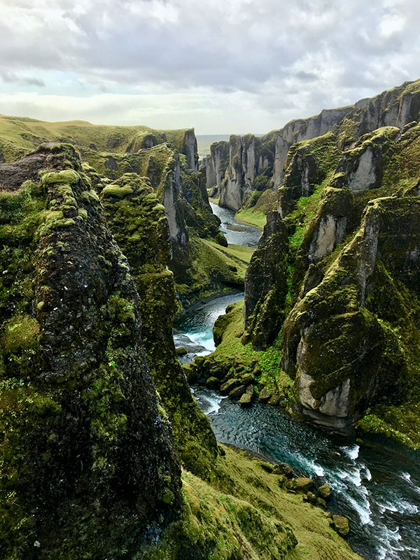
Fjaðrárgljúfur. Fjaðrárgljúfur (Fjadrargljufur Canyon). The Fjaðrá River flows through the weird formations of a gorge carved by soft tuff. In warm weather that fits the bill to wade and swim upwards the river in the canyon. Fjaðrárgljúfur is easily accessible from the Ring Road no1 6 km west from Klaustur (Laka-Holt F 206 road) a few kilometers detour from The Ring Road.
Dverghamrar. Dverghamrar (Dwarf Rocks) is the Ice Age mythological, strange, rocky formations of columnar basalt, molded by the waves when the sea level was higher. (The Ring Road, Route 1 – Just 15 km east from Klaustur).
Landbrotshólar. Landbrotsholar pseudocrater field, situated in the SE from the village of Klaustur, are formed steam explosions as flowing hot lava crosses over a wet surface, such as swamp, a lake or a pond. The explosive gases break through the lava surface in a manner similar to a phreatic eruption, and the tephra builds up Crater-like form which can appear very similar real volcanic craters.
Skaftáreldahraun. Skaftáreldahraun is a lava field, dressed with moss, from The Skafta Fires eruptions in 1783/84, west from Klaustur.
Kleifar. Is an ancient site of the regional assembly, near to the river Stjórn, with the waterfall Stjórnarfoss. From Klaustur drive/walk Geirland Road F-203, 2 km.
Núpsstaður. An old turf farmhouse standing at Núpsstaður, 32 kilometers east from Klaustur, together with an ancient church, one of the very few turf churches remaining in Iceland.
What to see – a day tour
Núpsstaðaskógur. Núpsstaðaskógur (Nupsstaða woods) is accessible from the Ring Road, Route 1, 40 kilometers east from Klaustur. Núpsstaðaskógur is a low growing shrubbery with warm springs and naturally carbonated springs with bizarre mineral deposit.
Skeiðarársandur. Skeiðarársandur, broad sandy wastelands, formed by many glacial bursts. The largest sand in the world, covering 1300 square kilometers.
Skaftafell National Park. Skaftafell National Park, located 70 kilometers east from Klaustur (The Ring Road, Route 1), is an oasis wedge between sand and glacier, established in 1967. Its unique natural beauty formed by the interplay of fire and ice.
Jökulsárlón. Jökulsárlón (Glacier Lagoon) is one of Iceland’s most spectacular vision, located 130 kilometers east from Klaustur (the Ring Road, Route 1). It’s 18 square kilometers and the deepest lake in Iceland, approaching a depth of 240 meters. This is widely regarded as the most picturesque scenery in all of south Iceland.
Eldgjá. Eldgjá (Volcan Canyon) is a 70 kilometers long volcanic fissure in Skaftártunga area in the highland. The Eldgja lava ( 18.000.000 cubic meters) flowed from the canyon. Accessible from the road F-208.
Lakagígar. Lakagígar (Laki Craters) (( stretch from tuff mountain Hnuta to the northwest through Mt Laki (818m) and at Vatnajökull. Laki)) consists of 115 craters extending 25 km along the tectonic fissure. The system erupted during 1783-84 (( purring out both basalt lava and clouds of poisonous acid „ Laki haze“ that killed 25 % of the population. The „Laki haze“ killed over six million people globally)). Mt Laki commands a splendid view of the craters and the surrounding landscape. Lakagígar is accessible from the Ring Road, Route 1, 6 km west from Klaustur (Laka-Holt F 206 road) and then 50 kilometers highland-road.
Langisjór. Langisjór (Long Lake) is a lake in the highland. It is around 20 kilometers in length and up to 2 kilometers wide. The lake water surface is 670 meters above sea level between the mountains Tungnárfjöll and Fögrufjöll in a beautiful and picturesque landscape. Langisjór is 90 kilometers.
Landmannalaugar. Landmannalaugar, a pearl of the interior, situated in a valley between colorful mountains at the dark edge of the lava field Laugahraun (Lauga Lava). Many hot and cold springs create a warm pool where people can bathe. It is 120 km from Klaustur, accessible from the road F 208.
Our location
Address Klausturvegur 1-5
880 Kirkjubæjarklaustur
Ísland / Iceland GPS
N63.47.174 W18.03.589 Location
Southeast, Iceland
Opening periods
Restaurant Open 17:30 – 21:30
Reception Open
7.30 – 10.30 and 16.00 – 21.30
Check-out until 10.30 hours / Check-in from 16.00 hours
Breakfast: Summer 7.30 – 10.30 . Winter/Spring 8.00 – 9.30